
This article is reprinted from the December issue of Dakota Country magazine, on newstands and in the mail this week.
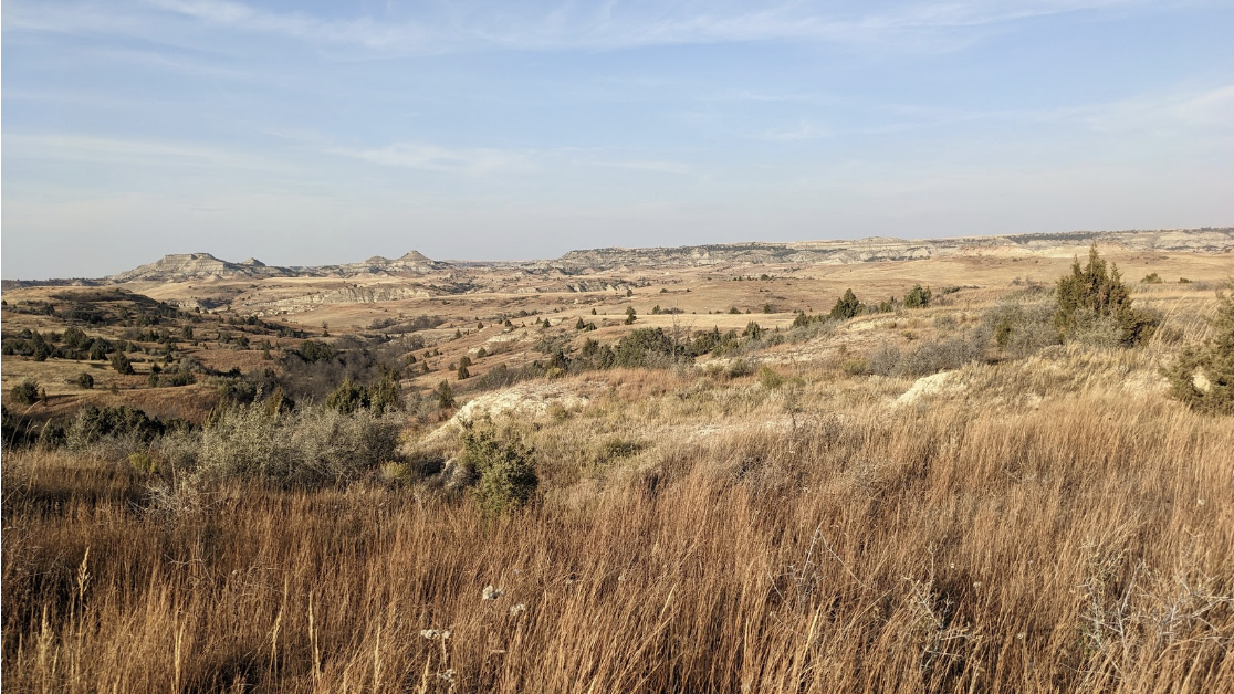
I wish I could tell you there’s a lot to see on Kendley Plateau, south of Medora, N.D. I wish I could, but I can’t, because there’s not much to see there. Mostly Bad Lands, prairie grass, sagebrush and scattered juniper trees. About 17,000 acres of that.
Oh, you might see bighorn sheep, or pronghorn antelope, or mule deer, or coyotes, foxes, golden eagles, redtail hawks or sharptailed grouse. They all live there at various times of the year. They like it because they aren’t often disturbed by the likes of us.
This is wilderness. If you want to be alone with the critters and the land and the sky, this is where you go. There are lots of great places in the North Dakota Bad Lands, and lots of humans go to them, on back roads, on the Maah Daah Hey Trail, or in a canoe on the Little Missouri State Scenic River. You won’t find any of those things on the Kendley Plateau.
It’s such a great place I’m even reluctant to tell you about it. It’s one of four areas of the North Dakota Bad Lands still classified as “Suitable for Wilderness.” I’ve written about the other three the past few months. The Kendley Plateau doesn’t have the obvious distinguishing features of the other three — the Little Missouri River valley of the Long-X Divide, the two readily visible peaks of the Twin Buttes, or the huge “island in the sky” called Bullion Butte. (Note to readers: I’ve got a story about Bullion Butte which I will share one of these days. I was hoping to climb it this fall so I could reclaim my self-proclaimed title “The Oldest Person To Climb Bullion Butte,” but various medical maladies prevented that from happening. In the Spring …)
But some have called the Kendley Plateau “The Heart of the Bad Lands.”
“Located at the core of the Little Missouri National Grassland’s southern extent, its juices pump soul into the meaning of Wilderness. Largest among Forest Service management’s Suitable for Wilderness, it is the culmination of Bad Lands diversity.
“Summits grant a powerful view stretching leagues in all directions. Canyons, valleys, and draws offer solitude and freshening rest.
“Seasonal wildflowers grace prairie, butte, and woody draw. The Rocky Mountain juniper — singly marking the landscape or in deep, moss-floored forests — also is found stunted, twisting from buffeted holds atop giant sandstone caprocks.
“Here is the puzzle tossed out on the landscape. Here, the myriad wild and rambunctious pieces fit. It is wild nature at its kaleidoscopic best.”
Dang, I wish I had written those words. But that’s part of the description of Kendley Plateau found in the proposal by the Badlands Conservation Alliance to create a federal Wilderness, with a capital W, in North Dakota’s Bad Lands. That hasn’t happened … yet. Maybe someday …

But let me tell you a little more about this place that I find a bit mystical and magical. It’s named for Lawrence Kendley, the son of a Billings County sheriff from Medora, who homesteaded there early in the 20th century.
I first went hiking there nearly 50 years ago, when the U.S. Forest Service’s Little Missouri National Grasslands map named it “Kinley Plateau.” There’s some mystery about that, but as near as I can tell, the mapmaker in that 1974 version of the map simply misspelled the name. Later versions corrected it to Kendley.
On a hiking trip there in more recent years led by the Badlands Conservation Alliance, our group found an interesting white, translucent rock, identified by one of our group as Shocked Quartz. That would have been Dr. Gerald Groenewald, one of the state’s best geologists, who happened to be on the hike, and who quickly told us of its importance. He knows that stuff. He’s the now-retired founder and director of the Energy and Environmental Research Center at the University of North Dakota.
I did a little digging — well OK, investigating, not really digging — when I got home, and I won’t quote all the sources from scientific journals, but the short version of the story is, a huge asteroid, as big as sixd miles wide, hit the earth on the Yucatan Peninsula in Mexico 65 million years ago and the shock waves were felt as far away as what are now the North Dakota Bad Lands, causing some mineral compressions, one of which we now call Shocked Quartz.

The event is also likely the one, some scientists say, which killed all the dinosaurs, and recent scientific articles are declaring that the event was “The Day the Dinosaurs Died.” Paleontologists are unearthing fossilized remains of those dinosaurs that died that day right now in Bowman County in southwest North Dakota, not so far from Kendley Plateau.
But you probably won’t find any dinosaur fossils on a hike or hunting trip to Kendley Plateau, and neither will you find oil wells or roads to disturb your visit. And it is the most accessible of the four proposed wilderness areas — you just drive south from Medora on the East River Road about four miles, past the Bully Pulpit Golf Course (you can stop there for a few hours and play 18 holes if you want) and turn right at the East River Road sign.
About 12 miles farther south, the top of the proposed area will be on your left, but go another 5 miles to a roadside spot called Tom’s Wash Trailhead on the Maah Daah Hey Trail, where you can park and cross the fence across the road for a hike into Kendley Plateau.
This is the spot that offers the easiest access to this wilderness area, and the beauty of it is, within five minutes you’ll find yourself completely isolated from the outside world. It’s relatively easy hiking as compared to Bullion Butte, which you can see if you turn around and look west, just a few miles away.

The elevation change from where you hike in to the top of the plateau is only about 400 feet, and it has pretty gentle slopes. Plan for a couple of hours in, a half-hour resting and looking around and a couple of hours back to the car — a nice afternoon excursion.
In fall, a shotgun over your shoulder might result in a couple sharptails in your vest. Early morning and late afternoon scouting at various points along six miles of the East River Road might yield pronghorn or mule deer spottings.
Best of all, the tavern and restaurant at the Rough Riders Hotel in Medora, where Teddy Roosevelt himself hung out during his frequent hunts here more than a century ago, are open year-around now and are great places to rest weary bones at the end of the day.
So now, I’ve told you a bit about all four of the still-pristine areas of the Bad Lands, and I hope inspired you to visit one or more of them. That pristine state is still not permanent, though, as long as a greedy oil industry is on the lookout for new places to drill their wells, and I’m part of a group that will continue to seek that permanent protection from the government.
It’s not easy to get federal Wilderness designation anymore, since it takes an act of Congress, and at least tacit approval from our own senators and congressman, who tend to side with the oil boys in situations like these.
But I’m hearing that discussions about creation of a National Monument, which can be done by presidential proclamation without congressional approval under the Antiquities Act, signed into law in 1906 by President Theodore Roosevelt himself, are ongoing among Badlands enthisiasts. Nothing formal, but still, discussions …
P.S. One more time, I’m going to encourage you to get a Forest Service map of the Little Missouri National Grassland. As I’ve mentioned before, the detailed maps (one-half inch equals a mile) show you all the public land owned or managed by the Forest Service, the BLM, the State of North Dakota (school sections) or the National Park Service. You can get them from the Forest Service office in Bismarck, at the visitor center at Theodore Roosevelt National Park, or from Doug and Mary Ellison at the Western Edge bookstore in Medora. I think they cost about $15. Or you can order them online at store.usgs.gov/fsmaps. It’s a good investment. With all the new oil roads in the Bad Lands, it’s pretty easy to get lost. Here’s map with the proposed Kendley Plateau Wilderness inside the gray border.
