
This article first appeared in the November, 2022 issue of Dakota Country magazine.
Long ago, way back in the 1970s, I lived in Dickinson, in western North Dakota, and was a writer and editor for The Dickinson Press. My regular working hours were 2 p.m. to 10 p.m. Monday through Saturday. I was a recently returned Vietnam veteran who needed to get away from the crowd whenever I could, and I took solace in the North Dakota Bad Lands.
Often, at most any time of the year except the dead of winter, I would head west on Saturday night, usually getting off the freeway at Exit 10, the Camel’s Hump Exit. Then I would usually roll out my sleeping bag and sleep under the stars on a spit of land reaching out into Camel’s Hump Lake, or if weather didn’t permit that, just sleep in the back of my 1972 Dodge van.
In the morning, I might throw a spoon out into Camel’s Hump Lake and catch a rainbow or two, and then I’d usually head north, to one of two big U.S Forest Service areas, a place we called the Bell Lake Wilderness, or the Twin Buttes. I’d hang out there until Monday morning, then head back to civilization to work.
The federal land in the Bell Lake area was a huge tract, about 50 square miles, and much of it was labeled “roadless,” so you had to park your vehicle and walk in. Today, sadly, it is called the Bell Lake Oil Field.
You could drive up pretty close to either of the Twin Buttes, but you had to stop at the fence and walk the rest of the way if you wanted to climb either of them.
I never did much climbing in the fall. Instead, I’d take my shotgun and zig-zag around the base and lower slopes, among the clumps of buffaloberry bushes, and hope a couple of sharptails would find their way into my vest. In other seasons, I’d just walk, and stop and sit on a rock, and in my mid-20s, having survived my stint in the military, ponder what I was going to do with the rest of my life.
I did that for much of three years before moving east and becoming a less-frequent visitor to the Bad Lands. But I still went, from time to time, and still do. And just a few weeks ago, on a beautiful fall day, I drove west from Bismarck, getting off the freeway at Exit 10, paused for a few minutes beside Camel’s Hump Lake, remembering those nights and mornings 50 years ago, and then drove north, straight to the Twin Buttes.
Once again, no sharptails found their way into my vest, but I ventured first to East Twin Butte, public land managed by the Forest Service still, and then over to West Twin Butte, stopping at the fence there because it is private land and I didn’t have permission to enter.
I spent a good bit of the day at East Twin Butte hiking around the south face, climbing just high enough to be able to look into the South Unit of Theodore Roosevelt National Park and, off in the distance, the winding green streak marking the valley of the Little Missouri State Scenic River as it snaked through the park.
Today, East Twin Butte is the centerpiece of one of the four areas designated by the U.S. Forest Service as “Suitable For Wilderness” that I’ve been exploring and writing about the last few months.
As I’ve mentioned in past articles, the Twin Buttes area, along with three other similar-sized areas of the Bad Lands, are the subject of the proposal by the Badlands Conservation Alliance and several other conservation groups, called Prairie Legacy Wilderness, to become officially-designated Wilderness, with a Capital W, under the federal Wilderness Act of 1964.
I visited two others, Bullion Butte and the Long X Divide, earlier this year and plan to reach the fourth, the top of Kendley Plateau, yet this fall before the snow flies. We’ll see. It’s getting late in the season. It might be a springtime trip.
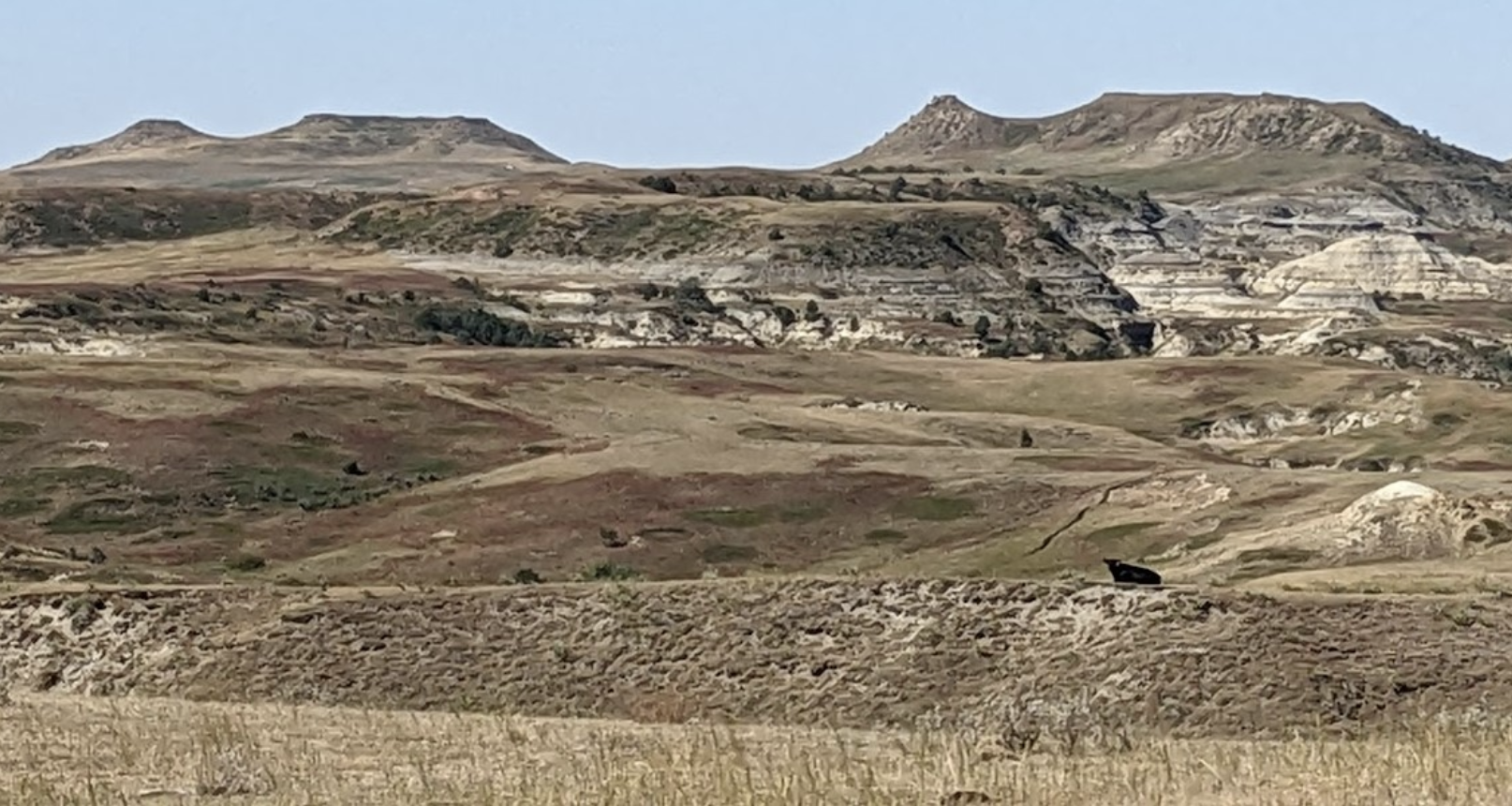
The buttes are called “twins,” because of their unique shape. Each has a flat mesa, and then a saddle leading to a smaller peak just a shade higher than the mesa. Interestingly, though, you can only see why they were named twins if you view them from the east. They look strikingly dissimilar viewed from any other direction. So whoever named them obviously first saw them as he or she approached them from the east.

So, the easiest way to get to them is north from Interstate 94, Exit 10, but the best view of them as twins is from the east, on Wannagan Creek Road, which you can get to if you get off I-94 at Exit 18. But here’s a word of caution: Don’t try to get there either way without a Forest Service map of the Little Missouri National Grassland.
The maps are very, very detailed, showing you all the public land owned or managed by the Forest Service, the BLM, the state of North Dakota (school sections) or the National Park Service. I’ve got a bunch of them because I’ve habitually over the years left home without one and then, realizing I needed one, I’ve stopped to buy a new one. You can get them from the Forest Service office in Bismarck, at the visitor center at Theodore Roosevelt National Park or from Doug and Mary Ellison at the Western Edge bookstore in Medora. I think they cost about $15. It’s a good investment. With all the new oil roads in the Bad Lands, it’s pretty easy to get lost.
Last month I shared with you the BCA description of the Long X Divide. Here’s what the BCA had to say about the Twin Buttes area in the proposal to classify the area as Wilderness.
“Intermittent sandstone caps in Twin Buttes create a haunting landscape, exposing dramatic hues of geologic deposition. Barren faces throughout the Bad Lands portion are captivating for the splendid color and harshness they offer. The flat-topped buttes and fallen columns of rock evoke feelings of walking through ancient ruins. Petrified logs are common in the area; in one instance stream erosion has created a petrified log bridge.
“On southern slopes, the flora consists primarily of native grasses, along with yucca, sage, and cactus. Draws and north slopes are sparsely wooded with ash, juniper, cottonwood, willow, wild plum and chokecherry. Much of the western portion is open rolling grassland.
“The area’s diverse terrain shelters pronghorn, mule deer, horned toads, prairie rattlesnake, coyote, jack rabbit, and prairie dogs. Hunters find the region well populated with game species and its landscape conducive to backcountry hunts reminiscent of bygone days.
“Dendritic fingers of Winter Creek fall off the eastern flanks of East Twin Butte, working northeasterly toward Wannagan Creek and the Little Missouri River. East Twin Butte offers a panoramic view of regional landmarks.
“Twin Buttes holds a special status as the only area in North Dakota ever recommended by the Forest Service for Wilderness designation.”
Nice words, BCA. Thank you.
Because of its proximity to the Interstate — it’s less than 10 miles from the Camel’s Hump exit — this is the easiest of the four proposed Wilderness areas to visit. At East Twin Butte, just park at the end of the gravel road on the southwest corner of the butte, slide under the stiff government fence, and you’re just a 15-minute walk to the saddle, with a nice view.

Fall is the best time to visit, because it’s cool and easier to hike. Take your shotgun. You might have more luck finding sharptails than I did on my recent September visit. If not, well, you’ve spent time in one of the best places in North Dakota. If you get a ways up the butte, you can even see Montana.
If you want to learn more about Wilderness, with a Capital W, visit the BCA website, badlandsconservationalliance.org.
One thought on “JIM FUGLIE: View From The Prairie — Twin Buttes: Wilderness And Maybe A Few Sharptails”
JIM FUGLIE: View From The Prairie — Kendley Plateau: ‘The Heart of the Badlands’ – UNHERALDED.FISH November 29, 2022 at 8:49 pm
[…] — the Little Missouri River valley of the Long-X Divide, the two readily visible peaks of the Twin Buttes, or the huge “island in the sky” called Bullion Butte. (Note to readers: I’ve got a story […]
Reply