
There’s something almost magical about stepping onto the prairie and knowing that it’s possible — even likely — that you’re the first person who has ever put their foot down on that spot. Ever.
One of the places you can do that is on the Long X Divide, near the extreme north end of the North Dakota Badlands.
Long X Divide. Even the name itself conjures up a little magic. Long X is the name of a famous 19th century cattle trail that ran from Texas to the Badlands of North Dakota, ending at the historic Long X Ranch.
And Divide brings to mind the Continental Divide, the Great Divide that sends waters of the United States flowing west into the Pacific Ocean or east into the Atlantic, the Gulf of Mexico or the Caribbean.
There are other lesser divides, or course, even one in North Dakota, called the Northern Divide, which runs diagonally through the state, from near Williston to west of Wahpeton. It divides the watersheds of the James River, which flows into the Missouri and eventually into the Mississippi and the Gulf of Mexico, and the Sheyenne, which runs into the Red River of the north and ultimately to Hudson Bay. It’s an interesting Divide because at places the James and the Sheyenne are just a few miles apart, but their waters will never mingle because of the Northern Divide.
The Long X Divide is not nearly so dramatic, and Divide is even a bit of a misnomer because while water flowing down the north side of the Long X Divide flows into the Little Missouri State Scenic River and the water running south drains into Corral Creek, after just half a dozen miles or so, Corral Creek runs into the Little Missouri as it makes its big bend and flows through Theodore Roosevelt National Park toward its confluence with the Missouri.

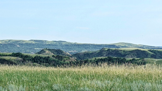
But geographers over the years have given it the distinction of a divide because it is noticeably visible from both the north and the south, rising some 600 feet above the Little Missouri, which flows past it just a couple of miles away. It appears to be about 3 miles long, east to west.
Unlike the jagged buttes of the Little Missouri River Valley that we call Badlands, the Long X Divide is a long series of round-top hills, providing a scenic backdrop to the Little Missouri River Valley when viewed from the overlooks in the park.
But enough geography. It’s the sheer pleasure of recreating on roadless prairies I want to talk about.
The Divide itself is pretty much in the center of a 10,000 acre expanse of Badlands hard up against the southern boundary of the North Unit of Theodore Roosevelt National Park. It’s managed by the U.S. Forest Service and classified as “Suitable for Wilderness.”

It’s one of four such areas the Forest Service gave that that label in its now 20-year-old Dakota Prairie Grasslands Management Plan, the resource management document for the million acres of National Grasslands (often more commonly called “the Government Pasture” by sportsmen) in western North Dakota.
Those four areas, totaling about 40,000 acres, which is about 4 percent of the federal land in western North Dakota, have been targeted by the Badlands Conservation Alliance for official designation as Wilderness with a capital W under the federal Wilderness Act of 1964. I wrote about their idea a couple of months ago, and also about another of the areas, Bullion Butte.
The title Long X Divide was given to the entire area by the BCA. It is one of the most remote and rugged areas of the Badlands as the Divide itself falls away to steep canyons in all four directions, many of them nearly inaccessible, except to native pronghorns and bighorn sheep.
But the Forest Service has done an admirable job carving out hiking trails throughout the wilderness areas — trails that are not for the faint of heart. The Long X trails coordinate with those of the park, providing some nice loop hiking experiences.
The famous Maah Daah Hey trail runs a 6.5-mile course through the proposed wilderness, criss-crossing the 8.5-mile Long X Loop and the 3.9-mile Summit Loop. A few years ago, I was part of a small group that hiked portions of all of them, a 12-mile “death march.” It was a spectacular hike on a cool spring day, through creek bottoms, cottonwood forests and a long narrow path along the face of a butte.
I wish I could say there are good maps of the trails in this part of the Badlands, but I haven’t found a good source. Your best bet is to find someone who’s done them before to guide you. Or just go there and have an adventure.
There are two primitive campgrounds on the edge of the Long X area, the CCC Campground and the Summit Campground. Both offer quiet solitude on summer evenings. Both are also access points to the nearby trails. You find them beside U.S. Highway 85 just south of the North Unit of Theodore Roosevelt National Park. And the national park has a modern campground accessible to recreational vehicle owners as well as tent campers.
Wildlife abounds in this area, of course, for hunters, birders and photographers. Hunting is walk-in only.
But in spite of the recreational opportunities this proposed wilderness area offers, it is just the idea of Wilderness, with a Capital W, alone, that has beckoned conservationists to seek federal designation and permanent protection, especially in light of the tremendous pressure on our natural resource agencies from the oil and gas industry.
Here’s what Wilderness supporters wrote in their proposal to our congressional delegation:
“As one treks up the broad valley of Summit Creek, south from the CCC Camp at the northern border of Long X Divide, the quiet is exaggerated by ringing in one’s ears.
“Slopes up and out of the canyon, and banks along the incised creek bed create benches vegetated with buffaloberry, silver sage, and higher up, Rocky Mountain juniper. Here is expansive solitude. This is wilderness.
“Switch-backing upward into higher tree country, one is awestruck by the vast forested green of Summit Canyon to the southeast and the contrasting aridity of Theodore Roosevelt National Park’s North Unit across the Little Missouri River to the north. Southern sister of the North Unit, the view from Long X Divide reveals a near desert aspect; reason enough to be called “Badlands.”
”Corral Creek, with its cottonwood, ash, chokecherry, and bermed evidence of flashfloods, meanders into west Long X Divide from the southeast. Cutting through remote canyons and rough terrain, it will journey beneath the southern flank of the Park’s Achenbach Hills and beyond.
“Pockets of aspen forest, rare to the Little Missouri River Valley, grant one more layer of color, auditory delight, and wildlife habitat.
“Expansive mixed-grass prairie uplands in central and northwest Long X provide rich primitive hunting opportunity — with common sightings of mule deer, bighorn, and elk.
“Long X Divide is the only Suitable area on the Little Missouri National Grassland that includes the mature cottonwood forest of its namesake— the Little Missouri River.”
There’s been no action in Congress on the Wilderness proposal, but supporters are also looking at the possibility of protecting the area, as well as the other three Suitable for Wilderness areas, as a National Monument. I hope they do that.

Reprinted from the September 2022 issue of Dakota Country magazine.
2 thoughts on “JIM FUGLIE: View From The Prairie — The Long X Divide Offers Wilderness Hiking”
JIM FUGLIE: View From The Prairie — Kendley Plateau: ‘The Heart of the Badlands’ – UNHERALDED.FISH November 29, 2022 at 5:58 pm
[…] the obvious distinguishing features of the other three — the Little Missouri River valley of the Long-X Divide, the two readily visible peaks of the Twin Buttes, or the huge “island in the sky” called […]
JIM FUGLIE: View From The Prairie — A New National Monument In North Dakota! – UNHERALDED.FISH November 25, 2024 at 11:31 pm
[…] special areas of the Bad Lands, places I’ve written about before, like the Kendley Plateau, the Long X Divide, and Twin […]