
I want to bring you up to date on the threats to the Elkhorn Ranch, Theodore Roosevelt’s ranch in the North Dakota Badlands, called by many the “Cradle of Conservation.”
It was there that the future president began developing his deep conservation ethic and later became our greatest conservation president ever.
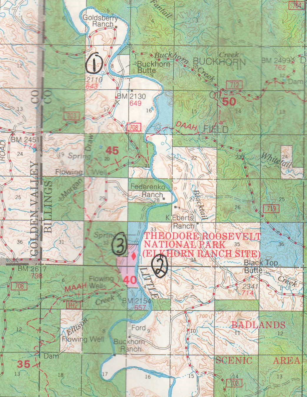
I’ve mentioned these things a couple of times in previous stories here — the desire by a local Billings County commissioner to build a new bridge across the Little Missouri River north of Medora, which you read about here, and the scheme by a Montana raconteur to dig a big gravel mine directly across from the Elkhorn Ranch site, located here. Both projects have made national headlines, and drawn national as well as local opposition because of the disturbance they would cause to this very special place in the heart of the North Dakota Badlands, and in the hearts of North Dakotans and all conservationists.

Figures no less important than the president’s great-grandson, Tweed Roosevelt, and the past executive director of the Boone and Crocket Club, Lowell Baier, have taken up the cause of the ranch, as have state conservation leaders and many of the country’s leading conservation organizations. And they’ve been successful — so far.
But the threats are more immediate now.
As if we haven’t had enough environmental disasters in western North Dakota as a result of the Bakken Boom, the worst of them all is about to start making its way to reality — the bridge over the Little Missouri River, deep in the Badlands, creating a monstrous truck corridor through the remote, fragile valley of the North Dakota’s only designated State Scenic River.
The Billings County website says that a Draft Environmental Impact Statement was scheduled to be released in “late spring-early summer” of 2015. But I just learned in an e-mail that the target date for release of that document is now “early 2016.” In that document, Billings County’s engineering firm will select a proposed route for the road and location for the new bridge. My guess is, that is academic — the bridge location has pretty much been narrowed down to one possibility, a place called the Goldsberry Ranch Crossing, about 30 miles northwest of Medora, as the crow flies. A lot farther by road.
Earlier, in response to a huge public outcry after public hearings in Bismarck and Medora in 2012, the original idea of putting the bridge beside the Elkhorn Ranch was discarded in favor of two other possible locations. But one of those locations is only about 15 miles north of Medora, where there are already two bridges across the river, and that location makes no sense. That just leaves the Goldsberry site among the options identified earlier as possible locations.
The good news, of course, is that the bridge and resultant “truck freeway” will not be right up against the Elkhorn Ranch, which is part of Theodore Roosevelt National Park, as originally proposed. But the Goldsberry Ranch Crossing is just four miles northwest of the Elkhorn, and the prevailing winds will carry the huge clouds of dust and the dull roar of truck traffic down the Little Missouri River Valley as sure as Teddy Roosevelt had “four eyes.”
And while any proposed location has been moved away from Roosevelt’s cabin site, national and state conservation leaders are still concerned about the damage the bridge and accompanying road will do to the Badlands environment. We’ll get a better sense of that, hopefully, from the EIS. If the engineering firm doing the job is honest with us, we’ll have some sense of what building a gravel road and bridge carrying up to 1,000 trucks a day — one of the estimates provided by the Billings County commissioner heading up the project — might mean to the land and wildlife in the nearby Badlands. And to hunters, hikers, birders, canoers, photographers and others who love to spend recreation time in the Badlands. Not to mention the ranchers whose land the trucks will roar through, day and night.
The threat to the environment is hard to imagine. Putting a thousand trucks a day, if that is what it turns out to be, on Badlands gravel roads, is totally irresponsible. That’s a truck every minute and a half over a 24-hour day, but much of the traffic will likely be daylight traffic, so we’re really talking about bumper to bumper truck traffic all day, every day. Imagine the dust clouds. Imagine the grass along the roads when the dust settles — unfit for deer or ranchers’ cattle to eat. Imagine the cacophony of brakes going down steep Bad Lands ravines. How do you even drive through dust like that? And the truck drivers are going to have to drive at least 35 or 40 miles of gravel to get from U.S. Highway 85 to state Highway 16, which the county commissioners say is their desired objective. It’s obvious they haven’t thought this through. I hope the engineers doing the EIS have. Personally, I think if this happens, within a year or two there will be a barren, mile-wide, 40-mile long, corridor through some of the most scenic parts of the Badlands.
I’ve spoken to the two ranchers who own the land on either side of the river where the likely proposed crossing is located, and neither has heard a word from the county or the engineering firm. Neither is very excited about the prospects, and hopefully they will show up at public hearings to voice their feelings about the project. Once the Draft EIS is released, a round of public meetings will take place, testimony for and against the project will be given, and a Final EIS will be published sometime next year. Then the wheels will start turning to put the state and federal funds in place to build it. We’ll be watching to see how much of this boondoggle will be paid for by taxpayers outside Billings County. I’ll keep you posted and explain how the project will be funded when I know more about that.
The second threat is the proposed gravel mine directly across the Little Missouri from the Elkhorn site, about a mile from Roosevelt’s cabin site. That land is owned by the U.S. Forest Service as a buffer to protect the ranch site and its viewshed from development, but what are known as “surface minerals” — gravel and scoria as opposed to oil and coal — are owned by kind of a scurrilous fellow from Montana named Roger Lothspeich, who apparently bought them from a trust or estate of a family of former owners of the ranch and then tried to blackmail the Forest Service into paying him off not to develop the gravel mine. His first asking price was something like $2.5 million, and the Forest Service didn’t bite.
Instead, they told him to go ahead and dig the gravel, and they put him through a rigorous permit process. The result was, a lot of safeguards have been put in place to make sure, as best as is possible, there is not a huge superfund site there when he is done. He’s posted a reclamation bond now and received his permit to rebuild the access roads and begin mining, but as of Aug. 1, there was still no activity at the site. That could change any day. Forest Service District Ranger Shannon Boehm, who will give the final go-ahead on the project, is still trying to meet with Lothspeich’s engineers to review plans for the road into the gravel mine site. Once Boehm signs off on the plans, road-building can begin. Whether it can be done before winter sets in remains to be seen.
Because mineral ownership trumps surface ownership, the fellow is entitled to dig out his gravel, but the Forest Service says it has done about all it can to make sure the disturbance is temporary. And there will be disturbance, for about the two-year life of the project. For a while, the Elkhorn won’t be the quiet meditative spot it has been for the last 125 years. We can just hope the bond will bring a concerted effort to reclaim the land atop the hill across from the ranch, as best as Badlands can be reclaimed. And hope that the Forest Service monitors the site closely, which will be difficult for them, given the scope of the other oil activity on their million acres in western North Dakota.
The irony in that, of course, is that it was Theodore Roosevelt, when he became president, who created the U.S. Forest Service. The agency that now manages the million acres of the Little Missouri National Grasslands. Roosevelt recalled his days in Dakota when, as the National Park Service points out on its website, “He became increasingly alarmed by the damage that was being done to the land and its wildlife.”
“He witnessed the virtual destruction of some big game species. Overgrazing severely impacted the grasslands, which also affected the habitats of small mammals and songbirds. Conservation increasingly became one of Roosevelt’s main concerns. After he became president in 1901, Roosevelt used his authority to protect wildlife and public lands by creating the U.S. Forest Service and establishing 51 Federal Bird Reservations, four National Game Preserves, 150 National Forests, 5 National Parks and enabling the 1906 American Antiquities Act, which he used to proclaim 18 national monuments. During his presidency, Theodore Roosevelt protected approximately 230,000,000 acres of public land,” the NPS website says. “Theodore Roosevelt was the nation’s 26th president and is considered by many to have been our country’s ‘Conservationist President.’ Here in the North Dakota Badlands, where many of his personal concerns first gave rise to his later environmental efforts, Roosevelt is remembered with a national park that bears his name and honors the memory of this great conservationist.”
“We have become great because of the lavish use of our resources,” Roosevelt once wrote. “But the time has come to inquire seriously what will happen when our forests are gone, when the coal, the iron, the oil, and the gas are exhausted, when the soils have still further impoverished and washed into the streams, polluting the rivers, denuding the fields and obstructing navigation . . . We have fallen heirs to the most glorious heritage a people ever received, and each one must do his part if we wish to show that the nation is worthy of its good fortune.”