
Bullion Butte: The Mother Ship (at least it is to me)
Where do I start, I ask myself?
How do I not make this dry and unreadable? How do I sort through my lifetime of memories of Bullion Butte and the files in our house? But start I will.
I’ve written before about the buttes of southwest North Dakota and my husband, Jim, most certainly has. My maternal ancestors certainly wrote about the buttes. My Mom and her sister, Junette, wrote long sections of the 1,178 page tome, “The Slope Saga,” as did the others in the area, all of whom I knew as a child and one of whom I saw this weekend at my mother’s funeral, the inimitable Dorothy Pearson, our neighbor about 5 miles to the east of our farm.
What had meaning to my ancestors at the time they were arriving from Norway and Germany was the landscape and the railroad and the county seats. (Technically, Bullion Butte is in Golden Valley and Billings counties.) And I know that Bullion Butte dominates the horizon from many vantage points along the valley of the Little Missouri River. I know this because as a little girl I listened to my elders talk of their personal experiences with the buttes of the area. And I know this because as I have written before when the farm work was caught up, my family enjoyed expeditions of the area, including to Camp Crook and to the Slim Buttes (SD), to Medicine Rocks (MT), Pretty Butte and Black Butte and White Butte and more. I know this because although the family farm was on the west fork of Deep Creek and the hills that surrounded us were our land, all one had to do was drive north roughly following the Little Missouri River and at some high point, there would be Bullion Butte.
Bullion Butte, where the Little Missouri River flowing north takes a huge bend and continues on to the mouth of the Missouri River. I know this because some of my earliest memories are of hiking up — yes, hiking, no roads there — Pretty Butte with my family, pushing my Grandma Lilly (by then in her 80s) up to the summit, pausing for a picnic and a rest, and back down. I know this because in the summer of 1966 my family went to Bullion Butte, all the way to the top, where my ancestors told stories in person of dances in the stone house they attended as young women and more. That stone house (the “Rock House”) still stands and is located on a tiny in-holding (private land) on the south face of Bullion Butte. (Consult the current Little Missouri National Grassland maps for boundaries.)
There is a spring there at the Rock House, which draws in the rattlesnakes in the summer. My family had an abiding knowledge and healthy respect of rattlesnakes as they are abundant in that landscape, including our farmyard. (An aside, how we children were never bitten by a rattlesnake is amazing to me, and my mother certainly dealt with many people at the Bowman Hospital who were bitten by rattlesnakes and suffered badly.)
I know about Bullion Butte because in 1970 or so when we would go to a branding (most often at a place on the southwest side of the river in those days) “up that way,” riding in the back of someone’s pickup on gravel roads, I can remember catching my breath when we got to a high enough point on the road that we could see that massive Bullion Butte with a dramatic June sky all around, a thunderstorm no doubt, and I was told, “no, that is not Slope County’s Black Butte.”
For reference, here is my note, written Sunday after we returned from burying my mother at Tuttle Cemetery, southwest of Rhame, N.D., a road trip that took us by White Butte, Chalky Buttes, Black Butte, Post Office Butte, Twin Buttes and then back home via Adams, Hettinger, Stark and Morton counties, all with more buttes. A road trip that included a dinner with my siblings at the Pasttime in Marmarth.

But back to the “Rock House” on Bullion Butte, built of prairie boulders and lumber. I can assure you that whenever we climbed Bullion Butte, we never trespassed. After all, my family knew all of the area’s people well and would never trespass (nor will I to this day). From “The Slope Saga”:
“BILL FOLLIS JR.
“Bill Follis (Bill Follis III) was born in Texas in 1865. When Bill was 7, his family trailed their herd of cattle to Colorado and settled near Trinidad. Young as he was, Bill helped with the drive.
“When he was about 18, he came to North Dakota and joined up with the 777 Ranch and became ranch manager. The Three Sevens was located eight miles north of Marmarth and owned by Berry-Boice, with Henry Boice as general manager. He was later promoted to foreman with the then good salary of $175 a month and became a representative, or “Rep” of the company with authority and responsibility to buy and receive cattle for his employes (sic) anywhere in the country. While ‘repping’ with the Marquis deMores ranch, he became well acquainted with Teddy Roosevelt, who was ranching in the area, and worked with him on several round-ups. Bill described Roosevelt as ‘a good mixer, even if he didn’t drink himself,’ and as a ‘fellow always willing to learn.’
“After the Three Sevens Ranch was sold, Follis bought some land and started his own ranching business, for which he became well known, but at the same time found the time to serve two terms as sheriff of Billings County. Bill received no salary but was paid mileage. He always insisted there was very little gunplay in the West and was always irritated by allusions to ‘the wild and wooly West’. He said that during his whole term as sheriff he could only recall one gun battle
“Eventually, Bill Follis built his herd to about 1,000 head of quality stock. He also took pride in his horses. His teams of workhorses, which he trained himself, were the envy of his fellow ranchers. Brandings were always great social events at the Follis ranches. A gathering of 100 adults from as far as 100 miles distant was not uncommon. The old-timers remember Bill as a great story teller, but he was never the hero of any of his yarns.
“In his years in this country Mr. Follis saw North Dakota ranching at its best and at its worst. When the Berry-Boice cattle company, the 777, kept track of expenses, they found it cost about 90 cents per head to keep cattle for a year. Pierre Wibaux, one of the first men Mr. Follis met in this section made a killing the year of 1897. He had gone to France the previous winter to raise funds for buying more cattle. In the meantime, the winter of 1886 struck, on Dec. 19 there was snow up to a horse’s knees. A chinook wind swept the snow away. The following morning everything was frozen solid and the cattle couldn’t paw through the icy cover for feed and a large percentage died. On his return, Mr. Wibaux found many ranches willing to sell the remnants of their herds. When he finished shipping he had 16,000 head of cattle clear. The cattle he shipped paid for themselves and the ones he kept.
“Bill Follis retired twice. He sold his last ranch in 1928 and moved to Dickinson to live, but when the crash of 1929 came, the man that had bought the ranch could not meet his financial obligations and Follis came back for another eight years of ranching.
“After his death, Bill Follis was elected to the Hall of Fame of Great Westerners by trustees of the National Cowboy Hall and Fame and Western Heritage Center.” page 16
“THE BOSSES TELLING BILL FOLLIS HOW TO RUN HIS OUTFIT BY ANDREW JOHNSTON IN “50 YEARS IN THE SADDLE” (Reprinted in “The Slope Saga,” page17.)
“William Follis Jr, was boss for the Three Sevens Berry Boice Cattle Company in the middle 1890s. At that time many small outfits were running cattle on the range, and when it came time for round up, they would all get together with the bigger outfits. The biggest outfits owned the roundup wagons and their boss was always boss of the roundup group.
“The large outfits usually had their hay up quicker than the smaller ones, due to the fact that they had different camps on their ranches. This year, the OX and the 777 outfits had finished putting up hay and wanted to get started shipping some of their cattle to market. So they started to round up some of the cattle, with representatives from only a few of the small outfits. The others were still finishing the haying.
“Henry Boice told Follis, ‘We will be shorthanded, but we will start the roundup. Mr. Gudgell and myself will have our string of horses and make regular hands for you.’
“They met at the 777 Ranch and started the wagon at a spring near where the town of Baker, Montana, now stands…..”
BILL FOLLIS SR.
FROM THE MARMARTH MAIL, DEC. 26, 1913
“After an illness of one night, J.W. Follis, Sr. died at his home near Ranger (a tiny town at that time in Slope County), at about age 80.
“Mr. Follis had been living on his claim, the house being a few rods from that of his son, J.W. Follis Jr. He had been sick during the night, and Roy Harmon, who had been staying with him, could not leave him to go to the ranch to notify the family, an account of the old man being violently delirious. Early in the morning, the sick man grew quiet and slept; taking advantage of the opportunity, Roy went to the house. When they arrived they found the aged man dead.
“Mr. Follis came to the Badlands from Texas in 1891, following his son who had come in about 1880, and had since made his home with his son. A short time before his death, he filed a claim near his son’s and built a cabin a few rods distant where he then lived. His life has been an eventful one, he having lived in the less settled country the greater portion of his life. He claimed to have been ’40 years a cowboy’. The funeral was held at the home of his son, and the burial was at the homestead. Many friends from Medora attended the services.
“The Walser ranch is now located on the Follis land. Mr. Follis was buried on a hilltop close by, and the graveside is still visible.” Marmarth Mail, Sept. 6, 1912 “Miss Anna Follis of Medora visited the Frank Gore and DeVasher homes.
“My great-aunt, Anna, youngest of the Hovicks and closest in age to my grandma Lilly, came to Bowman with her family members in 1913 and soon thereafter she and her sister, Lillian were cowgirls and sheepherders in the Powder River country southwest of Marmarth. “She (Anna) spent time with her sister, Bertha Holm, and then went up with Clara and Emma, who had homesteaded in Slope County near Bessie, N.D. In 1915, Anna had gone to the Glosser home to visit; and while there, the waters of the Little Missouri River had swelled making it impossible to cross. While on that side of the river she was a guest at the Bill Follis Ranch.” (“The Slope Saga”)


In my lifetime, I knew all of that generation of the Hovicks except for the two women who died before I was born, Clara and Bertha. And I knew all of my grandpa Andy Silbernagel’s siblings (one of which lived with her husband in Marmarth and the other in the Golva area). All of these folks are long dead now and I’ve attended many of their funerals.
———————-
From “Recollections of a Bad Lands’ Rancher,” by Elmer E. Ellis, North Dakota Historical Quarterly, Volume 1, No. 1
“A buffalo hunter called ‘Black’ John, who was reported to have killed 900 buffaloes the year before, had been engaged to serve as cook (circa. 1881-1884). They were to be accompanied by a trapper named ‘Jack’ Bullion, who with his partner, Reno, was located near the buffalo range. Howard Eaton was also to accompany them.
“The first night out of the ranch, they camped under a cut bank at a place known as Tepee Bottom. By hard traveling the second day, they arrived at Bullion and Reno’s shack on Bullion Creek, north of Bullion (Big) Butte. After resting here a day, they traveled east. The morning of the second day after leaving Bullion’s shack, the man from Michigan left the part, having had enough of Bad Lands travel.”
———————-
But now, going forward in time, here I give you a segment of the narrative from the WPA (Works Progress Administration, the years of the Great Depression, when my mother was born) Points of Interest from the Slope County folder held at the SHSND, copies of which are in my personal files.
“The Little Missouri River In Bowman & Slope counties,” by Clifford Puckett
“It is stated by geologists that at one time the valley of the Little Missouri was a fairly shallow channel except that portion near to where it emptied into the Missouri R.
“In just the same way as the Little Missouri wore a channel back from the Missouri R., the streams tributary to the Little Missouri wore deep gullies in the soft soils, and through thousands of years have made the Bad Lands.
“This river runs almost due north through Bowman and Slope counties, although it meanders in countless curves and bends on its way. The fall of the river is about 6 feet to the mile. The water flows at the rate of 6 miles per hour. The bed of the river is mainly covered with sand or gravel.
“Usually in late February or the first days of March. the early thaws break up the ice on the river. The floating pieces sometimes cause ice jams flooding the river bottom and damaging trees and whatever may be near the river.
“The amount of water carried annually by the river is from 500,000 to 1 million acres feet, varying with the rainfall. At various times devastating floods have occured (sic). In 1907, a terrific flood near Marmarth caused much damage, loss of live stock and farm equipment. Other floods have been suffered in the years 1913, 1921 and 1929. Two occured (sic) in ’21. The town of Marmarth on the river bottom in S.W. Slope County, and has been damaged by the floods several times.
‘In early days it was necessary to ford the river to get across. Now bridges are provided at important points on highways, etc. The fording method was difficult and dangerous on account of quicksand in the river bottom.
‘The water of the Little Missouri carries a great deal of silt brought in by its many tributaries still performing their work of erosion in the Bad Lands.
‘Sportsmen do not lack material for hunting along this river. The Bad Lands adjoining the river on both sides provides an ideal home for grouse, sage hens, prairie chickens and pheasants. Berry pickers find gooseberries, buffaloberries, choke cherries and currants in the gullies along the river all in their season. A considerable number of bears are found in the streams near the river where they do their work of building dams.
‘Several kinds of trees are found along this stream, including broad-leafed cottonwood, ash, red cedar, boxelder, choke cherry, elm, jack pine, willow, buffalo berry, dogwood, flowering currants and Rocky Mountain. type yellow pine.”
———————-
From “Ranching Days in Dakota and Custer’s Black Hills Expedition of 1874,” by Lewis F. Crawford, introduction by Usher Burdick, Wirth Brothers, 1950.
“The Bad Lands”
“A majority of the states of the Union have mountainous regions, and all the states have rough and hilly land, especially in the vicinity of the streams. Rough lands, however, do not necessarily mean Bad Lands. The term Bad Lands has always been applied to the particular picturesque landscape along the Little Missouri River in the western part of North Dakota. So far as we know, Baptiste Le Page was the first white man to explore this region, yet he has left us no description of the country. The name was given by the French, and means, when freely translated, “Bad lands to travel through.” The whites abreviated (sic) the name to Bad Lands. The term has no significance either of evil or of unfruitfulness, but refers wholly to the physical aspects which make them difficult to travel over.
“The Bad Lands begin in a small way on the upper part of the Little Missouri, where this stream enters North Dakota, at the southwest corner of the state, and grow gradually more abrupt, wider in extent, and of greater elevation above the river’s channel as we progress towards its mouth, reaching a maximum of brokenness some fifty miles above the Little Missouri’s confluence with the Big Missouri.
“The Little Missouri passes through a territory of slight rainfall, and except for an unusual soil formation, there could be no Bad Lands. Those who have never seen the Bad Lands, and know nothing of their formation may think of them as being of volcanic origin like the Lava Beds of Oregon, but they are not volcanic. The agencies responsible for the grotesque shapes of the Bad Lands are: first, and foremost, erosion, with some slight assistance from the burning of lignite beds, alternate freezing and thawing, and from winds.
“The question naturally arises, why do we have Bad Lands here in a region of slight rainfall, while regions of heavy rainfall do not have them? The general absence of stony formation is responsible. If this country had been armored with a hard stony formation, the Little Missouri would not have eaten its way down to its present bed level, nor would the collateral branches have been given an opportunity of cutting their deep and impassible channels.
“The Bad Lands region has no stone to speak of. The soil is clay which, when dry, holds its shape and position almost as stone, but when wet cuts away much faster even than loam soil would. The ground being unprotected by vegetation, erosion takes place on all sides, often forming slender spires and clay, fluted and corrugated by water.
“The Bad Lands cover a territory, roughly speaking, 200 miles in length by an average of 20 miles in width, or a total of 4,000 square miles. In some instances there is a drop in altitude to reach the channel of the Little Missouri from the outer rim, of over 1,300 feet.”
Crawford continues:
“Now, to quote from my book, ‘Badlands and Broncho Trails,’ ‘through the ages the Little Missouri and its numerous pitchy tributaries have been wearing their capacious channels deeper and deeper into the unarmored soil of this region. Clay is hard when dry, but soaked by a drenching rain it melts before the torrents that force their turbid contents through narrow defiles into the parent stream. The waters of the Yellowstone and the Big Missouri, glacier-born, are clear until defiled by the ochreous-throated gorges of the Bd Lands — and henceforth the Big Muddy runs true to name until its sordid waters mingle with the ‘all-embracing sea.’
“Unseen the Bad Lands can hardly be imagined, but once seen cannot be forgotten. The buttes are often wholly naked, as the erosion is so heavy that no vegetation, however creeping, can get a foothold. Ordinarily the south sides of the buttes are more precipitous and barren than are the north sides.
“Occasionally silicified stumps are found embedded in the clay of the buttes or forming a talus at their base. The burned-out lignite beds give evidence of the subsided bellicose passion within by the red burned scoria and the darker masses of aglutinated slag. The whole western part of North Dakota is underlaid with coal, and while large areas in the Bad Lands have been burned out, much remains. It is estimated that North Dakota has a greater tonnage of coal than is to be found in any other state in the union. It is not unreasonable to suppose that sometime in the future, the clays and the coal of the Bad Lands will be utilized in industry, bringing millions of wealth to our state. But until that time comes, the current wealth of the Bad Lands consists mostly of its grass, its scenery and the coal chiefly used locally.
“There are no better year-round grazing lands, in the United States, than the Bad Lands afford. This wealth consists chiefly of the short but nourishing buffalo grass, which is nutritious in the winter because it cures on the steam during the dry months of July and August.
“The feeding tentacles of buffalo grass hold the clay soil in place and prevent erosion from carrying the soluble and suspended particles into the wasted sea. Alternately seared by drought, frozen by the rigors of arctic winters and grazed and trampled to hopeless barrenness, yet it creeps forth from its subterranean vitality on the first relaxation of its enemies. With all of its staying qualities it retires before the plow without a protest, and quietly abides its time. If a field be abandoned, it is overrun by Russian thistles and other rank and reaching weeds, but within a few years, at most, the native grass quietly and unobtrusively reasserts its sovereignty.
“With its creeping benedictions, buffalo grass covers the scars of erosion, and only where a sunward declivity forbids the absorption of water is the surface left unclad. In our semi-arid regions it is the healing catholicon of nature — the antidote for barrenness; banish it and most of our western grazing lands would become as inhospitable as the Sahara.
“There is one feature of the Bad Lands that our people do not appreciate enough, and that is their value as a place of rest and refreshment. Everyone at times feels the need of a refuge from the woe-worn years, and no where can it be found more cheaply than among the delicate and wonderful freaks of our own Bad Lands. The psalmist said, “I will lift up mine eyes unto the hills, from whence cometh my help”. The hills will give strength. Go into the Bad Lands where you will, set up your tent by some refreshing stream and recover your old birthright. It makes no difference whether your tent be raised on some slope clothed in graceful herbage or in a gorge deeply furrowed with far-reaching ruin. Such places are all over the Bad Lands and are accessible by automobile roads. They may be reached from Marmarth, Belfield, Medora, Sentinel Butte, Grassy Butte, Watford City, Sanish or Killdeer.
“Less than 50 years have passed since the twang of bow and his of arrow could be heard here; when muscular bronzed men rode half-tamed ponies after the great bands of buffalo that ranged on her nutritious grasses.
“There is something inspiring and untamed about these hills, a soul-renewing solitude as yet unbroken by the tourist multitude.”
Other suggested sources:
Natural North Dakota May 5, 2021
BirdCast Billings County one example of the abundance of flora and fauna to be found by wanderers of the badlands this spring.
Kate Wolf “Some time let a back road take you home.”


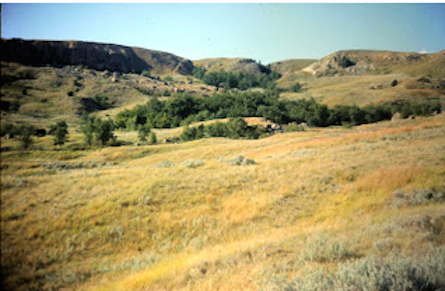
Bullion Butte Family Expedition, August 1966, from my family’s slide collection which my mother and I annotated in her last years in Mandan (all photos taken by my Dad).


